 Discoveries Discoveriesin the Velebit Mountains in 2000
|
 NAMBAWAN1
2001
NAMBAWAN1
2001First Polish expedition to Papua New Guinea
|
Grzegorz Kuśpiel
|
| Klub Speleologiczny "Aven" |
|
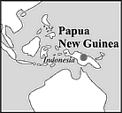
First reports on mighty, but difficult to reach karst massifs,
rising even as high as 3,500 m came from geologists employed in
gold mines in the neighbourhood of the settlement of Telefomin.
In one of such massifs close the Indonesian border cavers discovered
cave Selminum Tem. Operating under extremely harsh conditions of
tropical jungle, they explored over 20 km of underground galleries.
However, the cave developed mainly horizontally. The deepest cave
found at that time - Terbil Tem reached the depth of -354 m (location:
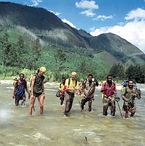
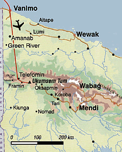
Fault Valley, Telefomin, Western Province, Papua New Guinea). In the equatorial jungle of Papua New Guinea On January 31, 2001, a huge Boeing 747 took off the Frankfurt Airport
apron so as to land in Indonesia fourteen hours later. Two intermediate
landings more and with the third we reached our destination, Jayapura.
Western Irian at last, our long dreamt of Papua. General Consulate
of Papua New Guinea resides in Jayapura. Obtaining visas didn't
cause any difficulties. On March 3, 2001, we pulled our boats out
of the water on the shore of Vanimo Bay3 and set our
feet on scorched soil of Papua.
The planned region of our exploration (Telefomin - the Victor Emanuel
Mountains) could only be reached by air. After an hour flight over
endless jungle we landed in rainy Telefomin, in the Victor Emanuel
Mountains. Altimeter pointed to 1,550 m above sea level and there
was no trace of Vanimo's heat. Mercury column didn't reach over
18oC. 1- NAMBAWAN means
"number one" in pidgin English |
 Cave
exploration of Papua New Guinea region is a domain of only few nations.
Among them the French take the most part. In the year 1998 they
set the depth record of the southern hemisphere (-1,178 m), while
exploring Murik-Berenice cave system (New Britain). Australians,
Germans and the English also explored New Guinea. Australians explored
probably the most known caves of Papua New Guinea. In the Muller
Range, province Southern Highlands, they discovered two caves: 54.8
km long and -528 m deep Mamo Kananda and 34.5 km long and -350 m
deep Atea Kananda2 . According to Australians, the potential depression
of baseline of the massif is estimated at 1,500 m. British expeditions
which explored New Guinea in the 70's and 80's were mainly interested
in the region of Hindenburg Mountains, situated in the centre of
the island, far away from civilization.
Cave
exploration of Papua New Guinea region is a domain of only few nations.
Among them the French take the most part. In the year 1998 they
set the depth record of the southern hemisphere (-1,178 m), while
exploring Murik-Berenice cave system (New Britain). Australians,
Germans and the English also explored New Guinea. Australians explored
probably the most known caves of Papua New Guinea. In the Muller
Range, province Southern Highlands, they discovered two caves: 54.8
km long and -528 m deep Mamo Kananda and 34.5 km long and -350 m
deep Atea Kananda2 . According to Australians, the potential depression
of baseline of the massif is estimated at 1,500 m. British expeditions
which explored New Guinea in the 70's and 80's were mainly interested
in the region of Hindenburg Mountains, situated in the centre of
the island, far away from civilization.